


The Red Arrows are set to soar over the Peak District this weekend. Great news…
Peak District Walks – 12 miles with amazing views
If you want to do one of our famous Peak District Walks, today’s 12 miles with amazing views could be just for you.
This walk was found on the brilliant website – Peak District Walks. If you click the link it takes you to the walk where there is additional information including GPX files and maps.
Bamford Edge, Stanage Edge, Derwent Edge from Ladybower Reservoir 12-Mile Route.
Walk information
- Walk type: Medium/long circular walk
- Distance: 11.6 miles/18.6 km
- Walk time: 6-7 hours
- Total ascent: 678 m/2,224 ft
- Highest point: 481 m/1,578 ft
- Walk highlights: Bamford Edge with views of Win Hill, Stanage Edge with a trig, Derwent Edge, The Wheel Stones and views of Ladybower Reservoir.
- Trigs: 1 – High Neb (Stanage Edge
- Ethels: 1 – High Neb (Stanage Edge)
- Stiles: 5
Walk start point
Start grid reference: SK 202 859.
The walk starts from the pay and display car park (£3 to park all day – cash only) at Ladybower Reservoir, a medium/large car park. Alternatively, you can start at Dennis Knoll car park, a small free car park with no facilities, this is further along the route.
Heatherdene car park, Ladybower Reservoir, Hope Valley, S33 0BY.
Facilities on the walk
Public toilets are available at the start of the walk at Heatherdene car park near Ladybower Reservoir.
There are two pubs near the end of the route (one just before and one just after) – The Ladybower Inn and The Yorkshire Bridge.
Bamford Edge, Stanage Edge + Derwent Edge route
Stage 1 – Ladybower Reservoir to Bamford Edge
- Distance: 1.6 miles/2.6 km
- Grid reference SK 202 859
From Heatherdene car park walk towards the toilet block to the right of the main parking area. Go down the wide path that runs parallel to the road which is beneath the trees. At the path junction, turn left here, heading away from Ladybower Reservoir. Walk straight uphill through the woods.
Continue uphill, across a small wooden bridge then over a wooden stile over a fence next to a stone wall. Walk alongside the wall continuing to head uphill, you’ll go through some trees and then through a gap in the wall. Finally, you’ll reach a path towards the top, turn right here and follow this all the way along for about 1 km until you reach Bamford Edge.
Stage 2 – Bamford Edge to Stanage Edge (High Neb)
- Distance: 3.5 miles/5.7 km
- Grid reference SK 2073 8495
Once you’ve explored the area around Bamford Edge continue in the same direction, following the footpath as it bears round to the left and alongside the edge heading southeast, then take the path heading downhill towards New Road, where you’ll go over a stile to the road.
Turn left and now follow the road all the way to a cattle grid that leads to Dennis Knoll car park (option to start the walk here if you’re driving).
Walk straight ahead, skirting around the green barrier. Follow this path as it bends around to the right and heads uphill towards Stanage Edge.
At the top of Stanage Edge take the rocky footpath heading left and walk along here where the path begins to widen. You’ll go over a wooden step stile and stay on Stanage Edge, the path can be muddy and wet in parts. After about 1.5 km you’ll reach High Neb trig point, also a Peak District Ethel, 458 m the highest point on Stanage Edge.
Stage 3 – Stanage Edge (High Neb) to Derwent Edge
- Distance: 4 miles/6.5 km
- Grid reference SK 2280 8534
From the trig point, after 1.5 km you reach the quarry area, take the path on the left picking up the Sheffield Country Walk. Go down the path, you’ll walk past the back of a green public footpath sign for Stanage Edge. Shortly after the sign, take the left-hand path towards the road and go over a wooden stile.
Turn left and walk on the narrow grassy verge alongside the road, it’s the worst bit of the walk but it’s short. After 500 m, cross over and go down the side road on the right. Then turn left signposted ‘Public Footpath via Derwent Edge’.
Walk down the track past the house, then just before the metal barrier look for a wooden post on the left. Follow this rough footpath as crosses over the brook, you may need to jump to avoid wet feet!
At the path junction, make sure you’re on the right of the wall, walk round and you’ll see another green public footpath signpost. Turn left here and walk uphill via the track next to the wall heading under the pylons. Go over the wooden stile (or metal gate if it’s open). Walk up the track, it splits further up, stay on the right-hand track and keep heading up past a stone grouse butt. Then you’ll reach the main path for Derwent Edge.
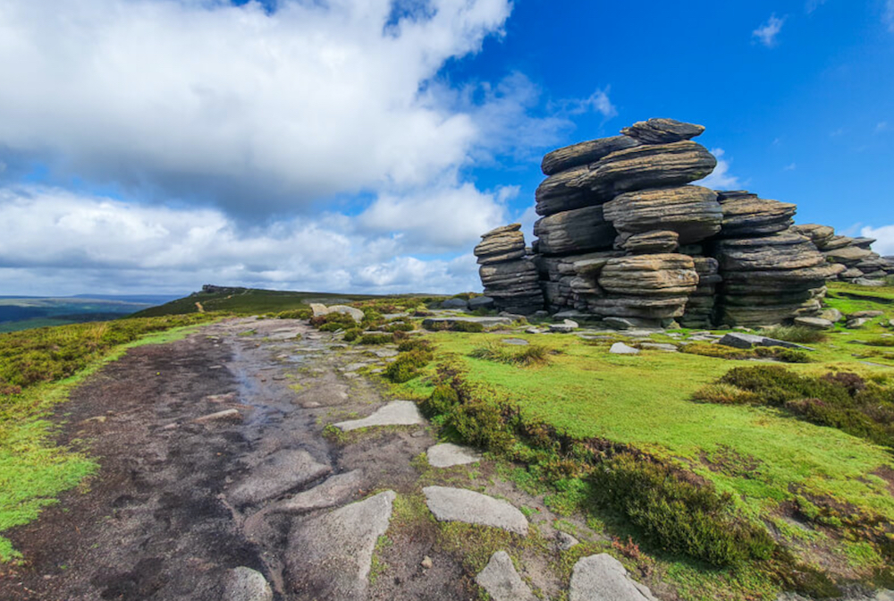
An option is to turn right here and head up to the Wheelstones, about 500 m. These are fascinating to explore and make a great place to stop for a break.
Stage 4 – Derwent Edge to Ladybower Reservoir
- Distance: 2.3 miles/3.7 km
- Grid reference SK 2016 8853
Once you’ve explored the Wheelstones on Derwent Edge head back down the path, at the cairn with the green public footpath signpost keep walking straight on, there are some beautiful views of Ladybower Reservoir from here. Follow the path around the edge where you’ll reach another path junction with several paths.
Keep walking straight on over the next hill Lead Hill and then follow the footpath as it takes you down a rocky path towards Ladybower Reservoir. At the path at the bottom turn left and continue down, through a wooden gate then to the end of the path which turns sharply right down to the road (there’s a steep shortcut if you prefer).
When you reach the road, turn right, past the Ladybower Inn, then turn left and go across the bridge on the pavement alongside Ladybower Reservoir. Walk down the pavement until you reach the entrance to Heatherdene car park on your left and you’re back at the start!
Walking holidays at Wheeldon Trees
Wheeldon Trees Cottages is the perfect location for walkers looking to explore Derbyshire and the Peak District. We offer a sanctuary for all the family and luxury accommodation to soothe tired limbs after a long day out.
Wheeldon Trees offers the perfect escape for your 2024 holiday.
10 stunning cottages
We have 10 stunning cottages in 12 acres of Peak District National Park. Alongside luxury cottages, our rural retreat offers EV charging and an honesty shop packed to the brim with goodies. In addition, we have a fantastic games room where you can play pool, air hockey or ping pong. We have two new electric bikes for you to borrow to explore the local area. What’s more, we have recently added two new hybrid bikes.
The Farmhouse is our flagship property. The cottage underwent a six-figure refurbishment in 2022 and today oozes luxury and style. Nadin, Ollerenshaw, Priestley and Mycock have also been upgraded in the last year.
Our three dog-friendly cottages are Critchlow, Lomas and Ollerenshaw. Sheldon Cottage is our fantastic accessible cottage with the best views in the house.
TripAdvisor recently named Wheeldon Trees in the top 10% of places to stay in the world. Thanks to our visitors’ amazing reviews, we recently received the TripAdvisor Travellers’ Choice Award 2023 for the second year running. To complete the hat trick, we were also the runner-up in best self-catering accommodation at this year’s Visit Peak District and Derbyshire Tourism Awards.
You can view our availability and pick your perfect cottage by following this link – view our availability.
Related Posts